Una delle edicole del sentiero della Madonnetta

Una delle edicole del sentiero della Madonnetta

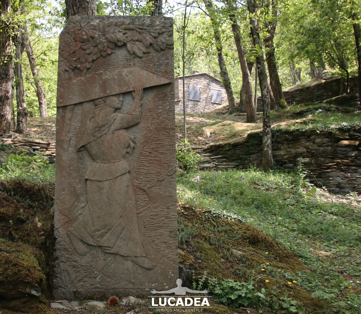
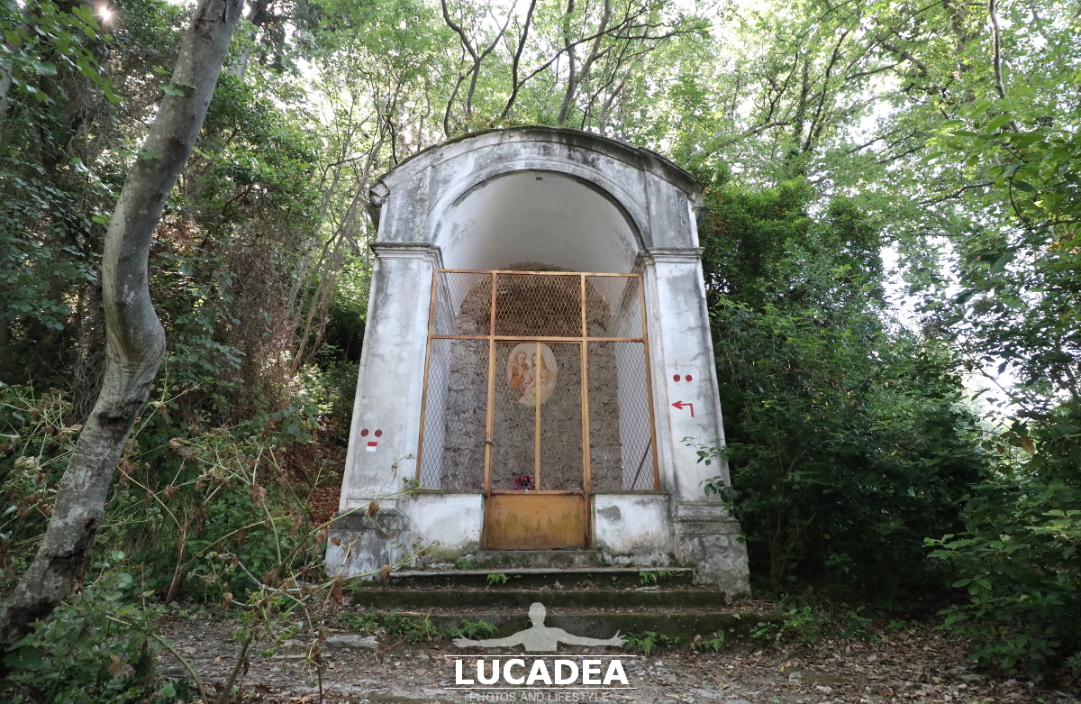
Una delle edicole del sentiero della Madonnetta.
Non sono un’esperto di questo sentiero e di queste cappellette, ce ne sono diverse lungo il sentiero che dal Parco Nelson Mandela sale fino al monte Castellaro e Punta Manara.
Qualche tempo fa avevo letto un post su Facebook dell’esperto Martino Tassano ma non saprei come recuperarlo ora. Si leggeva, se non erro, che il monte era quasi tutto dei monaci e i fedeli spesso vi creavano, in segno di ringraziamento, queste cappelle.
Sono tutte leggermente “trasandate” ma comunque non abbandonate!

La conosci? Aggiungi un comment or go to the bottom of the site to read what other visitors have written.

Photo taken with Canon EOS M100 and lens Canon EF-S 10-18.

Ecco dove si trova la edicola principale:

One of the votive shrines on the Madonnetta path – Un des sanctuaires votifs du chemin de la Madonnetta – Uno de los santuarios votivos del camino de la Madonnetta – Um dos santuários votivos do caminho Madonnetta – Eines der Votivheiligtümer auf dem Madonnetta-Weg – Một trong những ngôi đền vàng mã trên con đường Madonnetta – 圣母之路上的许愿圣地之一 – マドンネッタの小道にある奉納神社の 1 つ

Il crinale di Monasteroli

Il crinale di Monasteroli

Il crinale di Monasteroli.
Di solito quando si vede una foto di Monasteroli si vede la scalinata a picco sul mare che dall’alto del sentiero porta fino al mare.
Dal momento che mi sentivo a disagio a fotografare in quel punto (non soffro di vertigini ma un pochino mi infastidiva l’altezza) vi posto una foto delle case che poi formano il piccolo borgo.
Se notate poi la scalinata prosegue fino al mare e allo scoglio chiamato Scoglio Montonaio.

Conosci questo piccolo borgo e la sua famosa scalinata? Lascia un commento cliccando here.

Il crinale di Monasteroli

Photo taken with Canon EOS M100 and lens Tamron 16-300.

This is just one of the many images I took during the walk along the path that goes from Riomaggiore to Portovenere and of which I have made a special page, here:
foto gallery

Ecco dove si trova Monasteroli:

The ridge of the village of Monasteroli in Liguria seen from the trail – La crête du village de Monasteroli en Ligurie vue du sentier – La cresta del pueblo de Monasteroli en Liguria vista desde el sendero – O cume da aldeia de Monasteroli na Ligúria visto da trilha – Der Kamm des Dorfes Monasteroli in Ligurien vom Weg aus gesehen – Rặng núi của ngôi làng Monasteroli ở Liguria nhìn từ đường mòn – 从小径看到的利古里亚莫纳斯特罗利村的山脊 – トレイルから見たリグーリア州のモナステローリ村の尾根

Il mare spumeggiante di Liguria

Il mare spumeggiante di Liguria

Il mare spumeggiante di Liguria.
Le coste liguri sono spesso frastagliate e poco raggiungibili.
Questa, ad esempio, è subito dopo Riomaggiore (verso Spezia) e come potete vedere è molto aspra.
Mi sembra poi, che appena prima aver scattato, sia franato qualcosa in mare perché quella nuvola scura, in poco tempo, se n’è andata.

Il mare spumeggiante di Liguria

Photo taken with Canon EOS M100 and lens Tamron 16-300.

This is just one of the many images I took during the walk along the path that goes from Riomaggiore to Portovenere and of which I have made a special page, here:
foto gallery

The village of Vernazza in Cinque Terre in June 2020

Vernazza il 6 giugno 2020

The village of Vernazza in the Cinque Terre in June 2020.
The Cinque Terre are certainly among the most famous Ligurian locations in the world.
This is Vernazza and I photographed it a few days ago during a walk along the paths that connect the five villages.
In my opinion Vernazza is probably the most beautiful of the five.

Do you know Vernazza and the Cinque Terre? Add a comment or go to the bottom of the site to read what other visitors have written.

Vernazza il 6 giugno 2020

Photo taken with Canon EOS M100 and lens Tamron 16-300.

Here is where the village is located:

Starting from the West, it is the second of the villages that make up the Cinque Terre, nestled in a bay between the municipalities of Monterosso al Mare and Riomaggiore. It also includes the next village of Corniglia, its hamlet.
Continue reading on Wikipedia

Vernazza on 6 June 2020 – Vernazza le 6 juin 2020 – Vernazza el 6 junio 2020 – Vernazza em 6 de junho de 2020 – Vernazza am 6. Juni 2020 – Vernazza vào ngày 6 tháng 6 năm 2020 – 韦尔纳扎 2020 年 6 月 6 日 – 2020年6月6日のヴェルナッツァ

The trail to the Sanctuary of Montallegro in Rapallo

Il sentiero per il Santuario di Montallegro a Rapallo

The trail to the Sanctuary of Montallegro in Rapallo.
In recent weeks, like many others, I have become a lover of trekking.
I am lucky that in my area, the Ligurian Tigullio, there are many beautiful trails to hike.
So last week I went, together with some friends, to do the one that starts from Chiavari, passes by the Sanctuary of Grazie, goes to the Sanctuary of Montallegro and then ends in Rapallo.
A really nice ride of about 15 kilometers with some stretches (especially the initial one) that are really tough.
I'll leave you just a couple of photos here: the first is of the road that goes from Montallegro to Rapallo and that I took downhill; the second is of one of the many stretches of the trail.

Have you ever walked this trail? Add your own comment or go to the bottom of the site to read what other visitors have written.

Il sentiero per il Santuario di Montallegro a Rapallo

Il sentiero per il Santuario di Montallegro a Rapallo

Photo taken with Canon EOS M100 and lens Tamron 16-300.

If you want to see all the photos taken along the trail click here:
foto gallery

If you want to know more about this trail I invite you to go to the site: wikiloc.com.

The path to the Montallegro Sanctuary in Rapallo – Le chemin vers le sanctuaire de Montallegro à Rapallo – El camino al Santuario de Montallegro en Rapallo – O caminho para o Santuário Montallegro em Rapallo – Der Weg zur Wallfahrtskirche Montallegro in Rapallo – Đường dẫn đến Thánh địa Montallegro ở Rapallo – 通往拉帕洛蒙塔莱格罗保护区的道路 – ラパロのモンタレグロサンクチュアリへの道

The slate carriers in Cogorno

Le portatrici di ardesia a Cogorno

The slate carriers in Cogorno.
A monument dedicated to the women who had the hard task of transporting slate slabs from the quarries on the hills down to the valley along the path that is now called the slate path, above San Salvatore di Cogorno.

Do you know this trail?
Add your own comment or go to the bottom of the site to read what other visitors have written.

Le portatrici di ardesia a Cogorno

Photo taken with Canon EOS M100 and lens Tamron 16-300.

While this is the video of the walk:

Videos recorded with Gopro Hero5.

If you want to have more information about the trail I recommend: wikiloc.com.

To see all the photos taken along the climb to Mount San Giacomo and the slate path click here:
foto gallery

Slate is widespread in Northern Italy, it has been extracted for many centuries in Liguria, historically in the coastal area between Lavagna (hence the name) and Chiavari. Later also from the quarries of the Fontanabuona valley (behind Chiavari, Rapallo and Genoa) and in the Imperia area (Argentina Valley).
Continue and learn more on Wikipedia

The slate carriers in Cogorno in Liguria – Les porteurs d’ardoise à Cogorno en Ligurie – Los pizarreros en Cogorno en Liguria – Os portadores de ardósia em Cogorno na Ligúria – Die Schieferträger in Cogorno in Ligurien – Những người vận chuyển đá phiến ở Cogorno ở Liguria – 利古里亚科戈尔诺的石板搬运工 – リグーリア州コゴルノの石板運搬人

Il sentiero ad anello delle Cinque Torri a Chiavari

Il sentiero ad anello delle Cinque Torri a Chiavari

Il sentiero ad anello delle Cinque Torri a Chiavari.
In queste ultime settimane mi sono dedicato molto a passeggiare e a fare trekking lungo i sentieri della mia zona (e per fortuna ve ne sono molti e molto spettacolari).
Questo è quello che si vede pochi metri dopo la partenza dell’anello che parte da Chiavari (vicino all’ospedale) e arriva sempre a Chiavari (a Sanpier di Canne).
Non molto difficoltoso ma un pochino lungo (sui 15 Km).
La vista su Chiavari e sul mare però è splendida.

Il sentiero ad anello delle Cinque Torri a Chiavari

Photo taken with Canon EOS M100 and lens Tamron 16-300.

If you want to know more about this trail I invite you to go to the site: wikiloc.com.

Per vedere tutte le foto scattate lungo il sentiero clicca here:
foto gallery

Il sentiero per Punta Baffe

Il sentiero per punta Baffe

Il sentiero per Punta Baffe.
Questa mattina ho fatto una bella passeggiata tra le tante che il mio comune offre.
Sono andato fino a Punta Baffe e ritorno da Manierta.
Un bel giretto (da casa mia sono esattamente 10 Km) tra sentieri, piante e splendida vista sia verso Ponente (la vista su Riva Trigoso è splendida) sia a Levante (le coste verso Spezia).
Un percorso semplice ma con qualche bello strappo di salita. Molto ben indicato e soprattutto sentiero per curato.
Sul sito di promozione turistica di Sestri Levante sestri-levante.net c’è un bel articolo con mappe ed indicazioni.

Photo taken with Canon EOS M100 and lens Tamron 16-300.

Questo invece è il video che ho fatto salendo:

Videos recorded with Gopro Hero5.

The path to Punta Baffe in eastern Liguria – Le chemin de Punta Baffe dans l’est de la Ligurie – El camino a Punta Baffe en el este de Liguria – O caminho para Punta Baffe no leste da Ligúria – Der Weg nach Punta Baffe im Osten Liguriens – Đường dẫn đến Punta Baffe ở phía đông Liguria – 利古里亚东部通往蓬塔巴夫的道路 – リグーリア州東部のプンタ バッフェへの道

Riva Trigoso seen from the Punta Manara path

Riva Trigoso vista da Punta Manara

Riva Trigoso seen from the Punta Manara path.
A few days ago I enjoyed walking along the path that goes from Sestri Levante to Riva Trigoso passing by Mandrella and Punta Manara.
In addition to the splendid photographs that can be taken looking at Sestri (but you need a good telephoto lens) once you reach the tip of the promontory the view opens up on the Riva side and gradually on to the coast that goes towards the Cinque Terre.
In these three photos the splendid Riva Trigoso with its new bridge over the Petronio stream.

Know this trail > Add a comment or go to the bottom of the site to read what other visitors have written.

Riva Trigoso vista da Punta Manara

Riva Trigoso vista da Punta Manara

Riva Trigoso vista da Punta Manara

Photo taken with Canon EOS M100 and lens Tamron 16-300.

Here's also a beautiful video I recorded that day:

Videos recorded with Gopro Hero5.

Riva Trigoso seen from the Punta Manara path – Riva Trigoso vue depuis le sentier de Punta Manara – Riva Trigoso vista desde el sendero de Punta Manara – Riva Trigoso vista do trilho Punta Manara – Riva Trigoso vom Punta Manara-Pfad aus gesehen – Riva Trigoso nhìn từ con đường Punta Manara

Sestri Levante seen from the Rocche di Sant'Anna

Sestri Levante vista dalle Rocche di Sant'Anna

Sestri Levante vista dalle Rocche di Sant’Anna.
Anche se in questi giorni non si può ancora essere liberi di andare dove si voglia è stata liberata almeno la possibilità di passeggiare per i sentieri.
Qui a Sestri Levante, senza dover nemmeno uscire dal comune, ce ne sono diversi.
I più spettacolari sono quelli lungo la costa e principalmente sono tre (in ordine da Ovest verso Est):
– le Rocche di Sant’Anna: da Cavi Borgo a Petra Calante
– la Mandrella e Punta Manara: dal centro di Sestri fino a San Bartolomeo della Ginestra
– Punta Baffe: da Riva Trigoso a Moneglia

Ce ne sono anche molti da scoprire dietro la linea della costa e penso a Loto, San Bernardo, la Selva, Libiola, Villa Tassani ma non ne sono un conoscitore.

Vabbè forse ho divagato troppo. Questi sono gli scatti che ho realizzato ieri lungo il sentiero che va alle Rocche di Sant’Anna.

Photo taken with Canon EOS M100 and lens Tamron 16-300.

I'll also leave you a couple of videos I recorded the same day:

Sestri Levante seen from the fortresses of Sant’Anna – Sestri Levante vu des forteresses de Sant’Anna – Sestri Levante visto desde las fortalezas de Sant’Anna – Sestri Levante visto das fortalezas de Sant’Anna – Sestri Levante von den Festungen von Sant’Anna aus gesehen – Sestri Levante nhìn từ pháo đài Sant’Anna – 从圣安娜堡垒看到的塞斯特里莱万特 – サンタンナの要塞から見たセストリ・レバンテ